

Guidance on following the route
The route is not marked on the ground in any way and participants must use the event map (aided by their GPS device if necessary) to follow the route when required.
Mandatory route
From 2026, the Dragon’s Back Race® will follow a single mandatory route. This brings clearer stewardship, supports access discussions with landowners and authorities, protects sensitive terrain, and dispels the myth that shortcuts meaningfully affect outcomes, while keeping the race every bit as serious, beautiful, and navigationally demanding as ever. You can read more about the decisions behind this change here.
The digital version of the route
A digital version of the route will be available on the Avenza app. This will be shared in the final information before the event, giving people plenty of time to download it and get familiar with the app.
Gps devices
It will be possible for participants to follow the race route using just a GPS-capable device if you are experienced doing this. In this case, the paper maps could be stored in your pack (mandatory kit) as a back-up in case of power loss.
A dated version of the route is available via the route pages year-round so that aspirant participants and others can access the route digitally at any time, but it is important to understand that this does get amended ahead of each event.
We will provide final versions of GPX files for each day’s route to participants ~2 weeks before the event.
Information about checkpoints, and their associated cut-off times, and their associated guidance times, are included in the Avenza version of the route.
Sorry we cannot offer one-to-one technical support on how to upload these files onto your devices.
Following the route
As organisers, we (and friends, family, members of the public and landowners) will be tracking participants in real-time using the GPS trackers. We expect participants to follow the mandatory route without deviation, within a reasonable margin of error; Where the mandatory route line on the map follows a path, road or other obvious feature, participants are expected to follow that feature without deviation (e.g. no corner-cutting on zig-zags). When the mandatory route line uses a crossing point or bridge (or similar), the participants must use them [please refer to the event rules].
Across the more mountainous sections of the route where there is no visible path on the ground, participants should use the route as a guide and exercise their own mountain judgment to pick the best line across the terrain in front of them. We would still expect the deviation from the line to stay within 20-30 meters in these areas.

Navigating through Cymru ©No Limits Photography
Checkpoints
Along the route there are various Checkpoints that participants need to visit. These are not deliberately difficult tests of navigation, but logical points that define the route (generallymountain summits or a gate through a wall).
Participants will not see physical checkpoints on the ground, but their visit to the checkpoint will be confirmed remotely by a combination of live GPS data and remote timing readers. To ensure you are recorded as visiting a checkpoint, we recommend you touch the summit cairn.

An example of a checkpoint on the mountain summit of Tryfan on day 1 ©No Limits Photography
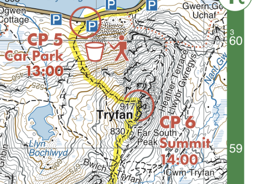
The corresponding section of the event map showing the checkpoint on Tryfan on day 1
ome examples of when we would time-penalise or disqualify a participant for not following the mandatory route would be any occasion on which we believe that they have gained an unfair advantage, and/or endangered themselves or others, and/or clearly passed through private property and/or climbed a farmer’s wall/fence.
In the case of accidental deviation from the mandatory route, participants should return to the original location that they deviated from the route and continue along the correct route. If participants correct their mistake in this manner, there will be no penalty or ‘strike’ (see comments in the event rules about ‘strikes’). Remember we will be watching!
Remember that the track of each participant will be public, and we will retrospectively review the route of all participants.
Participants are reminded that they are ultimately responsible for judging their safety on the route. In exceptional circumstances (like rivers in spate) participants may need to deviate from the route, making their best judgement of the safest way. In these circumstances, we would not penalise a participant.
The event map
Participants will be provided with their official event map at race registration. The event map is an accurate, waterproof and annotated Harvey map of the entire race route that has been specially commissioned by us. It will also be a fantastic memento of the event. If the participant is confident and experienced enough with map and compass navigation, they will be able to complete the event following the race route, using just the event map.
The event map contains information paramount to successful completion of the race.
As in the example below from the 2019 event, it will be a single-sheet, double-sided map. It will be 1:40 000 scale (1km = 2.5cm), with contours at 15 metres vertical interval. This topographic map shows all relevant hill and place names, a symbol legend, emergency protocols, all checkpoints, support points, and the route line. The map has been paginated so that it has a thoughtfully ergonomic day-stage chronology.

The 2019 event map
The nature of Harvey's latest waterproof paper technology means that the map does not require bagging/protection, is easy to fold and not bulky, and should survive the rigours of the roughest journey. We have already used this map material very successfully in other events. We do ask that you look after this map as we only intend to issue one per participant.